


RF Planner
وصف لـRF Planner
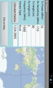
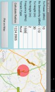
This is a simple application which can be used to do RF planning of a GSM, WCDMA, LTE or WiMAX site. The input parameters are the Tx Power, Rx Sensitivity, Tx Height, Rx Height and Frequency of operation. The output parameter is the Cell Radius which is used to plot the coverage area of the cell site on Google Maps. The coverage scenario can be selected from the following three options:
1. Urban
2. Suburban
3. Rural
The underlying model is applicable to Frequencies of up to 3500 MHz, Distances of 100-8000 m, BS Antenna Heights of 10-80 m and MS Antenna Height of 2-10 m.</div> <div jsname="WJz9Hc" style="display:none">هذا هو تطبيق بسيط والتي يمكن استخدامها للقيام التخطيط RF لGSM، WCDMA، LTE أو موقع واي ماكس. معلمات الإدخال هي الطاقة تكساس، آر إكس الحساسية، تكساس الطول، آر إكس الطول وتيرة العملية. المعلمة الإخراج هو نصف قطرها خلية والذي يستخدم لرسم منطقة التغطية للموقع الخلية على خرائط جوجل. يمكن اختيار السيناريو التغطية من الخيارات الثلاثة التالية:
1. الحضري
2. سوبربان
3. الريفية
نموذج الأساسي هو ينطبق على ترددات تصل إلى 3500 ميغاهرتز، والمسافات من 100-8000 م، BS الهوائي مرتفعات 10-80 م وMS هوائي ارتفاع 2-10 م.</div> <div class="show-more-end">
RF Planner - إصدار 1.0
(13-06-2016)RF Planner - معلومات APK
نُسخة APK: 1.0الحزمة: com.raymaps.rf.planner1آخر إصدار من RF Planner


تطبيقات من الفئة نفسها
قد يعجبك أيضًا...

 3.724.074.58
 4.064.012.65


